" class="zoomMainImage swiper-slide">
"
" alt="1786 Desnos and de la Tour offres Map of Egypt, West Africa and the Barbary Coast" width="527" height="527" />1786 Desnos and de la Tour Map of Egypt, West Africa and the Barbary Coast 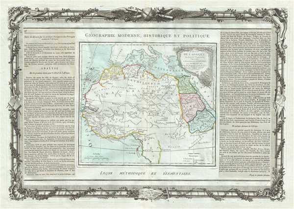 WE SELL ONLY ORIGINAL ANTIQUE MAPS - NOT REPRODUCTIONS Title: Partie De LAfrique en deca de lEquateur, Comprenant LEgypte, La Barbarie, La Nigritie etc. Description: This is a desirable 1786 map of northern Africa by French cartographer Louis Brion de la Tour. It covers the northern portion of Africa from the Maghreb or Barbary Coast south as far as Gabon. Like most maps of Africa from this period, the whole is rife with speculation. The White Nile flows south into the Ptolemaic Mountains of the Moon. According to Ptolemy, the Mountains of the Moon lay near two great lakes that were source of the White Nile. Today some regard this range and its lakes as speculative, but more likely it represents Ptolemys very real knowledge of Lake Victoria and the Rwenzori Mountains. A beautifully engraved title cartouche adorns the top right quadrant of the map. To the left and right of the map are paste downs of French text with remarks and description of the map. Surrounding the whole is an elaborate decorative border featuring floral arrangements, surveying tools, elaborate baroque scalloping, and a winged globe. This map was issued as plate no. 46 in the most deluxe edition of Desnos’ 1786 Atlas General Methodique et Elementaire, Pour l’Etude de la Geographie et de l’Histoire Moderne. Size: Printed area measures 15 inches high by 21 inches wide. Condition: Very good. Minor toning along original centerfold. Minor spotting at places. Original platemark visible. Minor overall toning. Shipping: Shipping rates are not negotiable. Items are shipped within three business days of receiving payment. We are happy to consolidate shipping where possible. The following shipping options are available: 1. FedEx Overnight (45 USD). USA Only. Signature Required. Customs: International buyers are responsible for paying duty and taxes on delivery. DHL or FedEx will contact the buyer by telephone to arrange tax payment if it is levied. Duty varies by country and we cannot predict the amount you will be charged. Some countries are duty free, others are not. Typically, a customs duty and/or VAT tax will be assessed on all parcels to continental Europe. Sometimes duty or tax is due in China, but is seems very random. Hong Kong, Singapore, Korea, and Taiwan have never assessed duty on a map we shipped. Maps shipped to the UK should be duty free as educational materials, but from time to time duty of 5% is assessed incorrectly by the UK customs agents. Insurance: All shipments are insured privately against loss and damage. All of our shipments require a signature for insurance purposes. If you have any questions please feel free to email us through eBay. Other Services Conservation Framing: Geographicus recommends basic conservation framing services for any antique paper. We do not offer this service. |

