
1966 USGS Geologic Map of the Moon: Mare Serenitatis Region 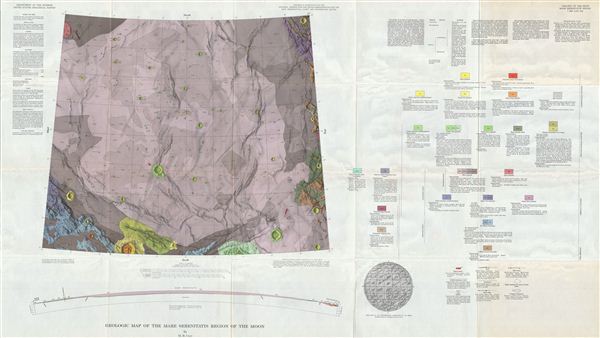 WE SELL ONLY ORIGINAL ANTIQUE MAPS - NOT REPRODUCTIONS Title: Geologic Map of the Mare Serentatis Region of the Moon by M. H. Carr. Description: A stunning full color geologic map of the Moons Mare Serenitatis, or ‘Sea of Serenity - better known to us as the ‘right eye of the Man in the Moon. The maps ghostly purple, punctuated by small, regular impact craters lends the map an eerily alien, worldly silence. Includes a sectional view of the mare from Montes Haemus to Posidonius (from the side), detailed text on the formation of the areas geology, extremely detailed ‘metadata explanating the mapmaking methodologies and symbols employed, and an index map showing the areas location on the Moon. This map represents a breath-taking leap forward not only in selenography (the study of the moon), begun in the late 1400s, but also in the record of humankinds fearless exploration of the world(s) around and beyond us. The Mare Serenitatis is a lunar mare, or large, dark basaltic plain, formed by ancient volcanic eruptions. It is bordered by Mare Imbrium, Mare Tranquillitatis, and Mare Vaporum. These dark spots were dubbed maria, or ‘seas, by early astronomers who mistook them for actual seas. These iron-rich plains are less reflective than the ‘highlands and thus appear dark to the naked eye. Mare Serenitatis is not only one of the lunar maria but also a mascon, or area of massive gravitational attraction. Both Luna 21 and Apollo 17 landed near the Mare Serenitatis. It is believed that most of the moons craters were formed approximately 3.9 billion years ago, during a period of intense bombardment in the Inner Solar System. The cratering rate fluctuates as collisions in the asteroid belt send fragment clusters into the Inner Solar System. This map might show hypervelocity impact craters caused by the same cluster of asteroids that, 65 million years ago, caused the extinction of the dinosaurs. As humans wouldnt land on the moon until 1969, how were we able to map its geology? The maps extraordinarily detailed metadata explains that the cartographers used photos dating back to 1960 (remember the series of Ranger missions in the mid-60s?), with relief created by measuring shadows, combined with an assumed sun angle and an assumed base elevation. The geology was arrived at from observing differences in, and layering of topographical forms, and in varying albedo (amount of reflected sunlight), both of which indicate different underlying materials formed under different processes. Goals of this work included the identification of suitable moon landing locations, and sources of oxygen for possible in establishing a more permanent lunar base. This map would be a great companion piece to the other maps in the Geologic Atlas of the Moon, especially those forming the face of the Man in the Moon. It would also wonderfully complement early explorers maps, or any of the plates from Burritts famous 1856 Atlas to Illustrate the Geography of the Heavens , one of writer H.P. Lovecrafts most prized possessions. Created by M.H. Carr and published as plate I-489 in the United States Geological Surveys Geological Atlas of the Moon. Size: Printed area measures 28 inches high by 49 inches wide. Condition: Very Good. Shipping: Shipping rates are not negotiable. Items are shipped within three business days of receiving payment. We are happy to consolidate shipping where possible. The following shipping options are available: 1. FedEx Overnight (45 USD). USA Only. Signature Required. Customs: International buyers are responsible for paying duty and taxes on delivery. DHL or FedEx will contact the buyer by telephone to arrange tax payment if it is levied. Duty varies by country and we cannot predict the amount you will be charged. Some countries are duty free, others are not. Typically, a customs duty and/or VAT tax will be assessed on all parcels to continental Europe. Sometimes duty or tax is due in China, but is seems very random. Hong Kong, Singapore, Korea, and Taiwan have never assessed duty on a map we shipped. Maps shipped to the UK should be duty free as educational materials, but from time to time duty of 5% is assessed incorrectly by the UK customs agents. Insurance: All shipments are insured privately against loss and damage. All of our shipments require a signature for insurance purposes. If you have any questions please feel free to email us through eBay. Other Services Conservation Framing: Geographicus recommends basic conservation framing services for any antique paper. We do not offer this service. |

" class="zoomMainImage swiper-slide">
1966 USGS Geologic Map of the Moon: Mare Serenitatis Region WE SELL ONLY ORIGINAL ANTIQUE MAPS - NOT REPRODUCTIONS Title: Geologic Map of the Mare Serentatis Region of the Moon by M. H. Carr. Description: A stunning full color geologic map of the Moons Mare Serenitatis, or ‘Sea of Serenity - better known to us as the ‘right eye of the Man in the Moon. The maps ghostly purple, punctuated by small, regular impact craters lends the map an eerily alien, worldly silence. Includes a sectional view of the mare from Montes Haemus to Posidonius (from the side), detailed text on the formation of the areas geology, extremely detailed ‘metadata explanating the mapmaking methodologies and symbols employed, and an index map showing the areas location on the Moon. This map represents a breath-taking leap forward not only in selenography (the study of the moon), begun in the late 1400s, but also in the record of humankinds fearless exploration of the world(s) around and beyond us. The Mare Serenitatis is a lunar mare, or large, dark basaltic plain, formed by ancient volcanic eruptions. It is bordered by Mare Imbrium, Mare Tranquillitatis, and Mare Vaporum. These dark spots were dubbed maria, or ‘seas, by early astronomers who mistook them for actual seas. These iron-rich plains are less reflective than the ‘highlands and thus appear dark to the naked eye. Mare Serenitatis is not only one of the lunar maria but also a mascon, or area of massive gravitational attraction. Both Luna 21 and Apollo 17 landed near the Mare Serenitatis. It is believed that most of the moons craters were formed approximately 3.9 billion years ago, during a period of intense bombardment in the Inner Solar System. The cratering rate fluctuates as collisions in the asteroid belt send fragment clusters into the Inner Solar System. This map might show hypervelocity impact craters caused by the same cluster of asteroids that, 65 million years ago, caused the extinction of the dinosaurs. As humans wouldnt land on the moon until 1969, how were we able to map its geology? The maps extraordinarily detailed metadata explains that the cartographers used photos dating back to 1960 (remember the series of Ranger missions in the mid-60s?), with relief created by measuring shadows, combined with an assumed sun angle and an assumed base elevation. The geology was arrived at from observing differences in, and layering of topographical forms, and in varying albedo (amount of reflected sunlight), both of which indicate different underlying materials formed under different processes. Goals of this work included the identification of suitable moon landing locations, and sources of oxygen for possible in establishing a more permanent lunar base. This map would be a great companion piece to the other maps in the Geologic Atlas of the Moon, especially those forming the face of the Man in the Moon. It would also wonderfully complement early explorers maps, or any of the plates from Burritts famous 1856 Atlas to Illustrate the Geography of the Heavens , one of writer H.P. Lovecrafts most prized possessions. Created by M.H. Carr and published as plate I-489 in the United States Geological Surveys Geological Atlas of the Moon. Size: Printed area measures 28 inches high by 49 inches wide. Condition: Very Good. Shipping: Shipping rates are not negotiable. Items are shipped within three business days of receiving payment. We are happy to consolidate shipping where possible. The following shipping options are available: 1. FedEx Overnight (45 USD). USA Only. Signature Required. Customs: International buyers are responsible for paying duty and taxes on delivery. DHL or FedEx will contact the buyer by telephone to arrange tax payment if it is levied. Duty varies by country and we cannot predict the amount you will be charged. Some countries are duty free, others are not. Typically, a customs duty and/or VAT tax will be assessed on all parcels to continental Europe. Sometimes duty or tax is due in China, but is seems very random. Hong Kong, Singapore, Korea, and Taiwan have never assessed duty on a map we shipped. Maps shipped to the UK should be duty free as educational materials, but from time to time duty of 5% is assessed incorrectly by the UK customs agents. Insurance: All shipments are insured privately against loss and damage. All of our shipments require a signature for insurance purposes. If you have any questions please feel free to email us through eBay. Other Services Conservation Framing: Geographicus recommends basic conservation framing services for any antique paper. We do not offer this service. |
" alt="Carte géologique de la offres Lune USGS 1966 : région de Mare Serenitatis" width="527" height="527" />
Carte géologique de la offres Lune USGS 1966 : région de Mare Serenitatis
Carte géologique de la offres Lune USGS 1966 : région de Mare Serenitatis, Carte géologique de la Lune USGS 1966 : région de Mare Serenitatis bien
€391.46
SKU: 5763012
Colour
"
1966 USGS Geologic Map of the Moon: Mare Serenitatis Region
WE SELL ONLY ORIGINAL ANTIQUE MAPS - NOT REPRODUCTIONS
Title: Geologic Map of the Mare Serentatis Region of the Moon by M. H. Carr.
Description: A stunning full color geologic map of the Moons Mare Serenitatis, or ‘Sea of Serenity - better known to us as the ‘right eye of the Man in the Moon. The maps ghostly purple, punctuated by small, regular impact craters lends the map an eerily alien, worldly silence. Includes a sectional view of the mare from Montes Haemus to Posidonius (from the side), detailed text on the formation of the areas geology, extremely detailed ‘metadata explanating the mapmaking methodologies and symbols employed, and an index map showing the areas location on the Moon.
This map represents a breath-taking leap forward not only in selenography (the study of the moon), begun in the late 1400s, but also in the record of humankinds fearless exploration of the world(s) around and beyond us.
The Mare Serenitatis is a lunar mare, or large, dark basaltic plain, formed by ancient volcanic eruptions. It is bordered by Mare Imbrium, Mare Tranquillitatis, and Mare Vaporum. These dark spots were dubbed maria, or ‘seas, by early astronomers who mistook them for actual seas. These iron-rich plains are less reflective than the ‘highlands and thus appear dark to the naked eye. Mare Serenitatis is not only one of the lunar maria but also a mascon, or area of massive gravitational attraction. Both Luna 21 and Apollo 17 landed near the Mare Serenitatis.
It is believed that most of the moons craters were formed approximately 3.9 billion years ago, during a period of intense bombardment in the Inner Solar System. The cratering rate fluctuates as collisions in the asteroid belt send fragment clusters into the Inner Solar System. This map might show hypervelocity impact craters caused by the same cluster of asteroids that, 65 million years ago, caused the extinction of the dinosaurs.
As humans wouldnt land on the moon until 1969, how were we able to map its geology? The maps extraordinarily detailed metadata explains that the cartographers used photos dating back to 1960 (remember the series of Ranger missions in the mid-60s?), with relief created by measuring shadows, combined with an assumed sun angle and an assumed base elevation. The geology was arrived at from observing differences in, and layering of topographical forms, and in varying albedo (amount of reflected sunlight), both of which indicate different underlying materials formed under different processes. Goals of this work included the identification of suitable moon landing locations, and sources of oxygen for possible in establishing a more permanent lunar base.
This map would be a great companion piece to the other maps in the Geologic Atlas of the Moon, especially those forming the face of the Man in the Moon. It would also wonderfully complement early explorers maps, or any of the plates from Burritts famous 1856 Atlas to Illustrate the Geography of the Heavens , one of writer H.P. Lovecrafts most prized possessions.
Created by M.H. Carr and published as plate I-489 in the United States Geological Surveys Geological Atlas of the Moon.
Size: Printed area measures 28 inches high by 49 inches wide.
Condition: Very Good.
Shipping: Shipping rates are not negotiable. Items are shipped within three business days of receiving payment. We are happy to consolidate shipping where possible. The following shipping options are available:1. FedEx Overnight (45 USD). USA Only. Signature Required.
2. FedEx Ground or Home Delivery (15 USD). USA Only. 1 - 10 days. If your address is a P.O. Box and cannot ship FedEx we will ship USPS Priority and, while we ship promptly, recent postal personnel cutbacks mean that delivery may take time. Signature Required.
3. FedEx International or DHL International EXPRESS (45 USD).
4. We can use your FedEx Account.
Customs: International buyers are responsible for paying duty and taxes on delivery. DHL or FedEx will contact the buyer by telephone to arrange tax payment if it is levied. Duty varies by country and we cannot predict the amount you will be charged. Some countries are duty free, others are not. Typically, a customs duty and/or VAT tax will be assessed on all parcels to continental Europe. Sometimes duty or tax is due in China, but is seems very random. Hong Kong, Singapore, Korea, and Taiwan have never assessed duty on a map we shipped. Maps shipped to the UK should be duty free as educational materials, but from time to time duty of 5% is assessed incorrectly by the UK customs agents.
Insurance: All shipments are insured privately against loss and damage. All of our shipments require a signature for insurance purposes.
If you have any questions please feel free to email us through eBay.
Other ServicesConservation Framing: Geographicus recommends basic conservation framing services for any antique paper. We do not offer this service.
Antique Map Restoration: Geographicus can repair and restore your antique map. Services include deacidification cleaning flattening and backing.
BEWARE anyone attempting to contact you, from a different eBay account, claiming to represent Geographicus Antique Maps. My eBay handle is GeographicusMaps. If you are contacted by email by someone offering you my items, please call me directly to be certain you are not dealing with a con artist." alt="Carte géologique de la offres Lune USGS 1966 : région de Mare Serenitatis" width="52" height="52" >
Personalised:: ( x )Personalisation:EditRemove PersonalisationAvailable From:
Buy now.
Pay later.
Earn rewards
Representative APR: 29.9% (variable)
Credit subject to status. Terms apply.
Missed payments may affect your credit score
FrasersPlus
Available Products
SIMILAR ITEMS
- Carte géologique de la Lune USGS 1966 : région de Mare Serenitatis
- TÜRKISCHE SEYYAL TANER SENI COK ÖZLEDIM+GÜLME KOMSUNA(NEUTRALER COVER)
- Le livre des malédictions : Contes vrais de vaudou, hoodoo et hexagonal par Stuart Gordon
- It That Heralds the End [Modern Horizons 3]
- Chaussures homme Nike Metcon Flyknit 3 AQ8022-300 pointure 9,5 séquoia citron brillant
- Publicité Advertising 0822 1952 Galeries Lafayette Studio dart
- Carte Pokémon : Lokhlass Ex Full Art 2024 Couronne Stellaire 158/142 NM ??
- GOUROU TERRE HUMAINE TERRES DE BONNE ESPERANCE LE MONDE TROPICAL PHOTOS
- Carte Pokémon Mustéflott 26/130 Reverse Diamant et Perle Français
- carte magic the gathering N1426 charme de la pépinière chevalier vaillant
Back to top